Turn on suggestions
Auto-suggest helps you quickly narrow down your search results by suggesting possible matches as you type.
Showing results for
- Good Sam Community
- Groups
- Bucket List Trips
- Forum
- Highway 20, BC - Closed
Options
- Subscribe to RSS Feed
- Mark Topic as New
- Mark Topic as Read
- Float this Topic for Current User
- Bookmark
- Subscribe
- Mute
- Printer Friendly Page
Highway 20, BC - Closed
Options
- Mark as New
- Bookmark
- Subscribe
- Mute
- Subscribe to RSS Feed
- Permalink
- Report Inappropriate Content
Jun-19-2017 07:34 PM
Highway 20, west of Williams Lake is closed until at least this weekend due to a major washout. There is a long and dusty detour in effect over some old logging roads. Certainly doable in an RV as long as you drive slow and share the road.
For those who are not familiar, Highway 20 goes from Williams Lake BC to Bella Coola on the central Pacific coast. Beautiful area and this washout could not have happened at a worst time with summer tourist season ramping up.

For those who are not familiar, Highway 20 goes from Williams Lake BC to Bella Coola on the central Pacific coast. Beautiful area and this washout could not have happened at a worst time with summer tourist season ramping up.
17 REPLIES 17
Options
- Mark as New
- Bookmark
- Subscribe
- Mute
- Subscribe to RSS Feed
- Permalink
- Report Inappropriate Content
Jun-29-2017 08:21 PM
It's open to horse and wagon traffic!
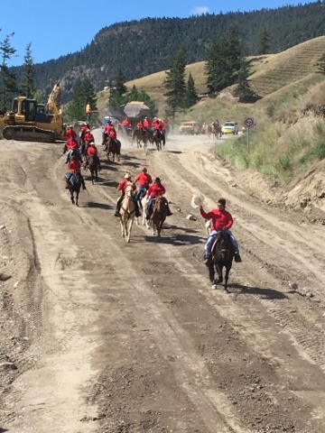
Chilcotin Riders Mount Up and Roll Out!
Friday - open with gravel through the construction zone.
Chilcotin Riders Mount Up and Roll Out!
Friday - open with gravel through the construction zone.
Options
- Mark as New
- Bookmark
- Subscribe
- Mute
- Subscribe to RSS Feed
- Permalink
- Report Inappropriate Content
Jun-27-2017 09:39 AM
Latest repair video (see side bar for earlier ones)
https://www.youtube.com/watch?v=f9Q0XH4fZyI
Also more pictures on the Flicker photostream. The captions talk about putting in drains, so ground water accumulation was a big concern. In contrast to the washout on Hwy 1 near Revelstoke (good photos on Flickr), this was not caused by a flash flood or mud flow from further up the valley. The upstream edge of the fill was barely disturbed, and the culvert doesn't seem to have been exposed.
closeup video before repair work
Options
- Mark as New
- Bookmark
- Subscribe
- Mute
- Subscribe to RSS Feed
- Permalink
- Report Inappropriate Content
Jun-24-2017 12:11 PM
When did the washout happen? It looks pretty dry now. How is a spring-time flood turned off so fast?
Options
- Mark as New
- Bookmark
- Subscribe
- Mute
- Subscribe to RSS Feed
- Permalink
- Report Inappropriate Content
Jun-24-2017 10:24 AM
The road opening has been pushed back to late next week. Change of travel plans for me...
Options
- Mark as New
- Bookmark
- Subscribe
- Mute
- Subscribe to RSS Feed
- Permalink
- Report Inappropriate Content
Jun-23-2017 08:53 AM
BC Flickr photostream
That repair photo and others is on the the BC Transportation Flicker photostream.
That repair photo and others is on the the BC Transportation Flicker photostream.
Options
- Mark as New
- Bookmark
- Subscribe
- Mute
- Subscribe to RSS Feed
- Permalink
- Report Inappropriate Content
Jun-21-2017 03:06 PM
paulj wrote:
The Williams Lake Tribune has drone footage of the washout. The embankment just downstream from the road is still sloughing.
That drone footage is from the same morning the washout occurred on.
As the work progresses, it now looks completely different. Official word is the highway is still on track to be re-opened this weekend.
Image is from about 4 hours ago.

Options
- Mark as New
- Bookmark
- Subscribe
- Mute
- Subscribe to RSS Feed
- Permalink
- Report Inappropriate Content
Jun-21-2017 12:55 PM
From google maps, I think the washout is a km up from the bridge:
https://goo.gl/maps/RRwSEBnQ33n
streeview is available. At this point the highway has climbed onto the first bench above the river.
Culvert plus fill can fail completely if the culvert get's clogged, the water ponds and then finds its own way through the fill.
Years ago, on the way back from Bella Coola I turned off of 20 before this grade (Riske Ck), and drove south to Gang Ranch and across the Churn Creek suspension bridge. That was long 90 mile gravel and dirt short cut. And this was a cute-ute, not a big RV.
The Williams Lake Tribune has drone footage of the washout. The embankment just downstream from the road is still sloughing. I
http://www.wltribune.com/
http://www.wltribune.com/news/overnight-highway-20-washout-closes-highway-sends-one-to-hospital/
It's interesting that there's little displacement or erosion among the trees and brush above road. The washout is entirely within the road fill and ravine sides downstream from there.
Last year there was a washout and sinkhole on us101 in Brookings OR. It was caused by a damaged culvert. It affected 101, a parkinglot and frontage road.
https://youtu.be/TR8FrGqx2kQ
Options
- Mark as New
- Bookmark
- Subscribe
- Mute
- Subscribe to RSS Feed
- Permalink
- Report Inappropriate Content
Jun-20-2017 02:16 PM
The update today stated that there is no conclusive cause for the washout.
“There was an existing culvert there, but we don’t have a root cause in the incidence. There isn’t one identifying feature in the field that is saying ‘this is what caused this.’”
It could be a combination of factors, he added.
“One could be high groundwater, there is a small creek in the area and we think it was certainly flowing, and we did have some water pooling on the ditch side of the embankment, but certainly nothing that would have been of a significant concern to us leading up to the incident.”
Agriculture irrigation does take place nearby but Hubner said there is nothing indicating it was a contributing factor at this time.
I was reading on FB that the reports yesterday morning that mentioned an irrigation pipe is because there is a largish irrigation pipe but further down to the bridge and people first thought that this pipe may have leaked for some time under the roadway which slowly undermined the soil and eventually caused the roadway to give way. Albeit, on a smaller scale, it is apparently not that all uncommon of a problem with old irrigation pipes in some older farm and ranch areas.
Options
- Mark as New
- Bookmark
- Subscribe
- Mute
- Subscribe to RSS Feed
- Permalink
- Report Inappropriate Content
Jun-20-2017 12:27 PM
romore wrote:
There is a lot of irrigation in the area for hay crops, that is beef cattle country. If a pipe had been leaking for some time the water may have been backed up then burst through a natural dam. We have had quite a time with road washouts here in B.C.
There are vary few irrigation systems that will provide that much water.
Unless there is a irrigation canal in the area above the wash out I really don't believe it was an irrigation system that caused this, simply because of the amount of water it would have taken to do this.
Nearly identical incident occurred on Highway 20 in Washington state. simply heavy spring runoff, pluged a culvert, and overflowed the road taking 350 yards of road bed with it.
Wa #20 closed
2000 Newmar mountain aire 4081 DP, ISC/350 Allison 6 speed, Wrangler JL toad.
Options
- Mark as New
- Bookmark
- Subscribe
- Mute
- Subscribe to RSS Feed
- Permalink
- Report Inappropriate Content
Jun-20-2017 09:23 AM
Tom/Barb wrote:
Thanks for the pictures, must have been one hell of a pipe to deliver that much water to do that much damage. we were just down 97, the Frasier is very high, and fast from all the runoff.
As I wrote last night, some reports yesterday morning mentioned an irrigation pipe that eroded the ground below the highway.
Remains to be seen what the real cause was and there is supposed to be an update later today or tomorrow morning.
Options
- Mark as New
- Bookmark
- Subscribe
- Mute
- Subscribe to RSS Feed
- Permalink
- Report Inappropriate Content
Jun-20-2017 09:07 AM
There is a lot of irrigation in the area for hay crops, that is beef cattle country. If a pipe had been leaking for some time the water may have been backed up then burst through a natural dam. We have had quite a time with road washouts here in B.C.
Options
- Mark as New
- Bookmark
- Subscribe
- Mute
- Subscribe to RSS Feed
- Permalink
- Report Inappropriate Content
Jun-20-2017 08:22 AM
Thanks for the pictures, must have been one hell of a pipe to deliver that much water to do that much damage. we were just down 97, the Frasier is very high, and fast from all the runoff.
2000 Newmar mountain aire 4081 DP, ISC/350 Allison 6 speed, Wrangler JL toad.
Options
- Mark as New
- Bookmark
- Subscribe
- Mute
- Subscribe to RSS Feed
- Permalink
- Report Inappropriate Content
Jun-19-2017 09:30 PM
Tom/Barb wrote:
Google maps doesn't show any farm land at the 12 mile point on #20 west of Williams Lake. mostly forest and one ravine after another.
There is 1 big circle farm much farther west. operating off its own wellhead.
The washout is about 25 kms (15 miles from the Highway 97 junction.) As you cross the Sheep Creek bridge at the Fraser River, the road rises then curves to the right. This image I took in 2013, is from the east side of the bridge looking west. The sliver of highway in the top left is where the washout occurred.

And yes, there is farmland up and to the right of the highway there. Here is a good image of the area.(Not my image.)

I'll be up there in a couple of weeks and the highway should be all repaired by then.
Options
- Mark as New
- Bookmark
- Subscribe
- Mute
- Subscribe to RSS Feed
- Permalink
- Report Inappropriate Content
Jun-19-2017 08:07 PM
Google maps doesn't show any farm land at the 12 mile point on #20 west of Williams Lake. mostly forest and one ravine after another.
There is 1 big circle farm much farther west. operating off its own wellhead.
awesome washout tho.
165 yards of road bed gone.
Ill bet the guy who got washed away had to have clean draws when they got him out.
There is 1 big circle farm much farther west. operating off its own wellhead.
awesome washout tho.
165 yards of road bed gone.
Ill bet the guy who got washed away had to have clean draws when they got him out.
2000 Newmar mountain aire 4081 DP, ISC/350 Allison 6 speed, Wrangler JL toad.


